Map - Concelho da Beira

Concelho da Beira
 
Map - Concelho da Beira
Map
Openstreetmap - Map - Concelho da Beira
Openstreetmap
Map - Concelho da Beira - Esri.WorldImagery
Esri.WorldImagery
Map - Concelho da Beira - Esri.WorldStreetMap
Esri.WorldStreetMap
Map - Concelho da Beira - OpenStreetMap.Mapnik
OpenStreetMap.Mapnik
Map - Concelho da Beira - OpenStreetMap.HOT
OpenStreetMap.HOT
Map - Concelho da Beira - CartoDB.Positron
CartoDB.Positron
Map - Concelho da Beira - CartoDB.Voyager
CartoDB.Voyager
Map - Concelho da Beira - OpenMapSurfer.Roads
OpenMapSurfer.Roads
Map - Concelho da Beira - Esri.WorldTopoMap
Esri.WorldTopoMap
Map - Concelho da Beira - Stamen.TonerLite
Stamen.TonerLite
Country - Mozambique
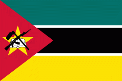
Flag of Mozambique
Mozambique (Moçambique, ; Mozambiki; Msumbiji; Muzambhiki), officially the Republic of Mozambique (República de Moçambique, ), is a country located in southeastern Africa bordered by the Indian Ocean to the east, Tanzania to the north, Malawi and Zambia to the northwest, Zimbabwe to the west, and Eswatini and South Africa to the southwest. The sovereign state is separated from the Comoros, Mayotte and Madagascar by the Mozambique Channel to the east. The capital and largest city is Maputo.

Notably Northern Mozambique lies within the monsoon trade winds of the Indian Ocean and is frequentely affected by disruptive weather. Between the 7th and 11th centuries, a series of Swahili port towns developed on that area, which contributed to the development of a distinct Swahili culture and dialect. In the late medieval period, these towns were frequented by traders from Somalia, Ethiopia, Egypt, Arabia, Persia, and India.
Currency / Language  
ISO Currency Symbol Significant figures
MZN Mozambican metical MT 2
ISO Language
PT Portuguese language
Neighbourhood - Country  
  •  Malawi 
  •  South Africa 
  •  Swaziland 
  •  Tanzania 
  •  Zambia 
  •  Zimbabwe 
Language